SD8338X powerful long remote surveillance & combat drone, SD8338S combat drone, SD8338R remote surveillance drone, SD8338P combat drone, SD8338B multi-purpose drone (reconnaissance, surveillance and combat UAV with bomb), SD8338F cleaning drone with a flame-thrower, SD8338W rinse drone, agricultural drone & FPV drones as follows:
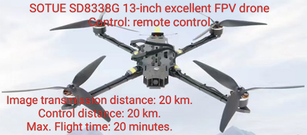
SOTUE SD8338G 13-inch excellent FPV drone
Application:
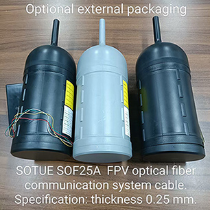
SD8338G excellent FPV drone is a kind of reconnaissance, surveillance and combat drone, normally widely used to reconnoitre and monitor enemies, enemy's buildings and dangerous objects and also used to forest fire prevention and border patrol. Optional use: 13-inch or 15-inch or 18-inch or 20-inch or 25-inch or 30-inch FPV drone which is flying with SOTUE SOF25A optical fiber communication cables will not be jammed by any equipment and will be controlled safely and very reliable. SOF25A optical fiber communication cables are as shown below.
Technical data:
1. 13-inch reinforced carbon-fiber frame and 4D-printed parts.
2. 13-inch propellers HQ1310 Polymer carbon-fiber (4 pcs) HQProp.
3. Video transmitter VTX 5.8GHz 5W AKK.
4. Battery 8S5P 20000 mAh.
5. Receiver: Elrs 2.4 GHz.
6. Motor 4214 380KV.
7. Flight Control F722 + 80A ESC.
8. Camera Caddx Ratel Pro 1500TVL.
9. Antenna 5.8G 160mm 4.9-6.1G.
10. RadioMaster TX15 MAX - Mid Range – 20 Km.
11. FPV goggles Skyzone SKY04X V2.
12. Flight time: 20 minutes.
13. Payload: Max. 4 kgs.
Technical standards:
European CE and EMC international security standard certificates.
Optional use: SOTUE 15-inch or 18-inch or 20-inch or 25-inch or 30-inch excellent FPV drone which is flying with SOF25A optical fiber communication cables will not be jammed by any equipment and will be controlled safely and very reliable.
Optional use: SOTUE SOF25A FPV optical fiber communication system cable can be used by any FPV drone, its optional lengths are 5 km, 10 km, 15 km, 20 km, 25 km, 30 km and 50 km or can be customized according to a client's need.
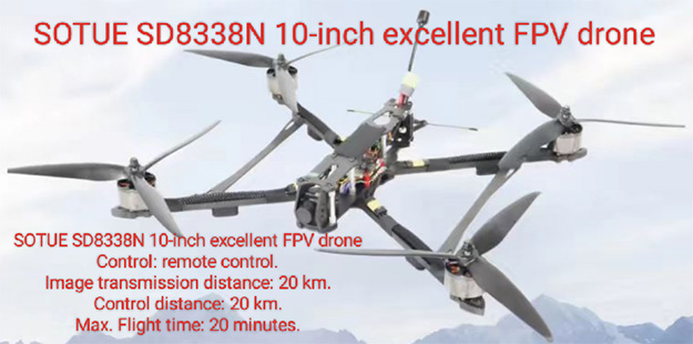
Optional FPV drones: 15-inch or 18-inch or 20-inch or 25-inch or 30-inch excellent FPV drone can be customized for a client's need. For example as shown below:
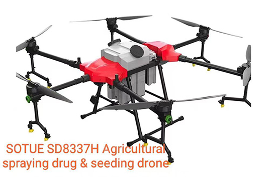
Agricultural drone: If you are interested in it, please contact us to get its catalog.
SOTUE SD8338S combat drone
SD8338S combat drone is a kind of reconnaissance, surveillance and suicide combat drone and normally widely used to reconnoitre or attack enemies, enemy's building and dangerous objects.
Technical data:
Overall dimensions: 750 mm x 560 mm x 150mm (when it is unfolded.)
Max. rising speed: 8 m/s. Max. descent speed: 8 m/s.
Horizontal flight speed: 25 m/s, 90 km/hour.
Max. load: 4 Kgs, recommended load: 3 Kgs.
Standard flight time: ≥ 40 minutes (no load).
Charging time: 30 minutes.
Power supply: 110V ~ 220V (± 10%), 50/60Hz.
Work environment temperature: -40 ℃ ~ +70 ℃.
Flight altitude: ≥ 5,000 meters.
Flight humidity: < 90%.
Flight height: ≥ 1,000 meters.
Hovering accuracy: Vertical ± 0.5 m (when GPS positioning is working normally). Horizontal ± 1.5 m (when GPS positioning is working normally).
Feature:
1. Flight modes: manual, automatic, fixed height, fixed point, motion, attitude.
2. Satellite positioning module: GPS / GLONASS, BDSS / GLONASS, dual mode GPS and Beidou satellite (triple positioning). 3. Control method: APP ground station or remote control.
4. Operation: 1 person.
5. Task load: It can provide multiple interfaces and simultaneously hang multiple task loads. 6. Security system: equipped with identity recognition and backend data supervision.
7. Control: The aircraft can switch to different control stations at any time during flight or hovering, and it can operate normally.
Remote control with integrated ground station:
Screen size: 5.5 inch high-definition highlight (clearly visible in the sun) screen with touch function.
Resolution: 1920 x 1080.
Memory: RAM: 4G; ROM: 16G.
System: Android 5.1.
Work frequency: 2.4GHz dual frequency.
Max. control distance: 10 KM (in an open space without any interference).
Internal battery: 7.4V, 10000mAh, Lipo 2S.
Video output interface: HDMI video, support QGC, support wireless RTSP video sharing.
Other interfaces: SDK and protocol documentation.
Data retrieval: reserve TX RX to retrieve flight data.
Display type: support multi-screen display (video window, ground station window displayed simultaneously).
Optional: autonomous flight and ground station:
1: Support for switching between multiple maps of Google China, Google and AMAP.
2: The APP ground station can view real-time aircraft flight status images, videos, voltage, satellite coordinates, height, speed, distance, and mission routes
3: 300 waypoint flight missions can be set, including automatic drop-off, route flight, one click takeoff, one click landing, autonomous cruise, low pressure return, out-of-control return, etc.
4: Support safety protection such as the original route return, landing nearby, hovering in place, climbing and return.
5: Equipped with warning function, self-checking flight status, automatic alarm and automatic return when encountering faults.
6: The flight log is stored in real time and can be exported.
8x three axis zoom camera:
Work temperature: -25 ℃ ~ +70 ℃.
Number of stable axes: 3 axes.
Work voltage: 24V.
Degree of vibration: ± 0.03 °.
Control signal: PWM SBUS serial communication.
File storage: SD card (128G).
Video output interface: micro HDMI high-definition output, network port, serial port.
Video output resolution: 1080P.
Sensor: CMOS 1/2.3, 5 million effective pixels.
Focal length: 24 ~ 240 mm.
Optical zoom: 8x.
Focusing mode: automatic.
Focusing time: < 1s.
Resolution: 1920 x 1080.
Work mode: photograph and video recording (1080P).
Cross collimator aiming system.
Optional: Drop-off bomb rack:
1. Throwing accuracy: ≤ 1m (at a height of 100 meters without wind or gentle breeze).
2. Throwing mode: single shot (can be hung vertically or horizontally).
3. Ammunition bomb capacity: 1 piece.
4. Drop-off rack caliber: 60 ~ 82 universal (can be customized) (can hold all items weighing less than 2 kilograms in standard).
5. Cross collimator, automatic buckle locking.
6. Communication protocol: SBUS/PWM.
Technical standards:
1. Conform to EN 60950-1:2006+A2:2013 product safety international standard.
2. Conform to EN 61010-1:2010 product safety international standards.
3. Conform to EN55011:2016 product safety international standard.
4. Conform to EN61000-3-2:2014 product safety international standard.
5. European CE and EMC international security standard certificates.
SOTUE SD8338B multi-purpose drone
SOTUE SD8338B multi-purpose drone is a kind of reconnaissance, surveillance and combat UAV and normally widely used to reconnoitre or attack enemies, enemy's building and dangerous objects.
Technical data:
Overall dimensions: 1178 mm (L) x 1081 mm (W) x 619 mm (H) (when unfolded).
Max. rising speed: 20 m/s.
Max. descent speed: 5 m/s.
Max. wind speed: Level 8.
Max. load: 28 kgs.
Suggested load: < 20 kgs.
Flight time: ≥ 85 minutes (no load).
Environment temperature: -30 ℃ ~ +70 ℃.
Flight altitude: ≥ 5,000 meters.
Flight humidity: < 90%.
Flight height: ≥ 2,000 meters.
Battery: LiHV 14S.
Voltage: 62.3 V.
Capacity: 62,000 mAH.
AC input: 110V ~ 220V (± 10%), 50/60Hz.
Charging time: 40 minutes.
Feature:
1. Flight modes: manual, automatic, fixed height, fixed point, motion, attitude.
2. Satellite positioning module: GPS / GLONASS or BDSS / GLONASS dual mode GPS Beidou satellite (triple positioning).
3. Hovering accuracy: vertical: ± 0.05 m (when GPS positioning is working normally), horizontal: ± 0.05 m (when GPS positioning is working normally).
4. Protection level: IP67 dustproof and waterproof, suitable for flying in moderate rain weather.
Control method: APP ground station or remote control.
Task load: It can provide multiple interfaces and simultaneously hang multiple task loads.
Security system: equipped with identity recognition and backend data supervision.
Control: The aircraft can switch to different control stations at any time during flight or hovering, and it can operate normally.
Remote control with integrated ground station:
1. Screen size: 7-inch high definition highlight (clearly visible in the sun) screen with touch function.
2. Resolution: 1920 x 1080
3. Memory: RAM: 4G, ROM: 16G.
4. Max. control distance: 20 kms (in open spaces without interference).
5. Data postback: advancely reserve TX RX postback flight data.
6. Sharing: Can wirelessly share data to the command hall (computer or TV.).
7. Transmission method: All three networks support 4G, 2.4G, WIFI and wired transmission.
Optional: autonomous flight and ground station:
1. Support for switching between multiple maps of Google China, Google and AMAP.
2. It can preset waypoints and flight route tasks, it can also edit routes and waypoint tasks in real-time.
3. The APP ground station can view real-time aircraft flight status, images, videos, voltage, satellite coordinates, altitude, speed, distance and mission routes.
4. It can set 600 waypoint flight tasks, automatic throw, route flight, one click takeoff, one click landing, autonomous cruise, low pressure return flight, incontrollable return flight, etc.
5. Safety protection such as original route return flight, landing nearby, hovering in situ, climb-out return flight, etc
6. Equipped with early warning function, self-checking flight status, automatic alarm and automatic return when encountering faults.
7. The flight log is stored in real time and can be exported.
8x zoom tracking night vision three-axis thermal imaging camera
Resolution: 640 x 512.
Lens focal distance: 25 mm.
Digital zoom: 8x.
Work temperature: -25 ℃ ~ 70 ℃.
Mode setting: Direction lock, flight direction follow, camera facing down.
Sensor: CMOS: 1/3, 8 million effective pixels.
Focusing mode: automatic.
Image resolution: 1920 x 1080 Pixels.
Working mode: photograph and video recording (4K).
Optional: Drop-off Bomb rack:
1. Throwing angle: vertical to the ground.
2. Throwing accuracy: ≤ 1m (in a height of 200 meters and a gentle breeze).
3. Throwing mode: one bomb / double bomb / overall bombs.
4. Number of bomb: 3 ~ 6 pieces.
5. Caliber: 60 ~ 80 universal (other calibers can be customized.)
6. Aiming method: crosshairs.
7. Filling method: automatic buckle locking. Anti-detachment design.
Technical standards:
1. Conform to EN 60950-1:2006+A2:2013 product safety international standard.
2. Conform to EN 61010-1:2010 product safety international standards.
3. Conform to EN55011:2016 product safety international standard.
4. Conform to EN61000-3-2:2014 product safety international standard.
5. European CE and EMC international security standard certificates.
SOTUE SD8338P powerful Combat Drone
Application:
SOTUE SD8338P combat drone is a kind of reconnaissance, surveillance and combat UAV, normally widely used in battle, rescue, counter-terrorism and security to reconnoitre and monitor enemies, enemy's building and dangerous objects and also used to forest prevention and border patrol.
Technical data:
Dimension: 2,000 mm (L) x 2,000 mm (W) x 730mm (H) (when unfolded)
Max. ascending speed: 12 m/s.
Max. descent speed: 2 m/s
Flight speed: Positioning mode: 5 m/s. Motion mode: 8 m/s. Attitude mode: 20 m/s.
Wind speed: Level 6.
Max. load: 25 Kgs.
Effective flight time: 60~ 65 minutes (flying with a payload of 6 kilograms in an environment of the wind speed level 6).
Charging time: 40 minutes.
Power supply: AC 110V~240V.
Work environment: -20 ℃ ~ +70 ℃.
Flight altitude: ≥ 5,000 meters.
Flight humidity: < 90%.
Flight height: ≥ 2,000 meters.
Flight modes: manual, automatic, fixed height, fixed point, motion, attitude.
Satellite positioning: GPS / GLONASS or BDSS / GLONASS, dual-mode GPS Beidou satellite (triple positioning).
Protection level: IP56 dustproof and waterproof, suitable for flying in rainy weather.
Optional: equipped with identity recognition.
Flight mode: equipped with course lock, HOME point lock and surround flight.
Shooting angle: 0~45 ° (adjustable in real-time).
Shooting mode: single shot / continuous shots.
Intelligent remote control integrated with the ground station:
Screen size: 7 inches, with touch function.
Resolution / width: 1920 x 1200 / 1000nlts.
Memory: RAM: 4G, ROM: 16G.
Battery life: ≥ 10H.
Max. control distance: 10 km (in open spaces without interference).
Data return: Reserve TX RX to postback flight data.
Display type: Support multi screen display.
Data sharing: can wirelessly share data with the command hall (computer or television).
Transmission method: All three networks support 4G, 2.4G, WIFI and wired transmission.
Autonomous flight ground station:
1: Support multiple map switching: Gaode Map, Google China, Google Map.
2: Can preset waypoints and route tasks, and can edit routes and waypoint tasks in real-time.
3: 600 waypoint flight tasks can be set: automatic throw, route flight, one click takeoff, one click landing, autonomous cruise, low-pressure return, out-of-control return, electronic fence, etc. (In unexpected situations such as low voltage, excessive aircraft attitude vibration, signal loss, penalty fences, etc., the drones will autonomously return and land).
4: Support safety protections such as returning on the original route, landing nearby, hovering in place, climbing and returning.
5: Flight logs are stored in real-time and can be exported.
Dual photothermal imaging pod:
Work temperature: -25 ℃ ~ 70 ℃.
Number of stable axes: 3 axes
File storage: SD card (256G).
Video output resolution: 1080P.
Sensor: CMOS: 1/3, 8 million effective pixels.
Focal length: 4.7~28.2 mm.
Min. object distance: 30 m.
Optical zoom: 6x.
Comprehensive zoom: 10x.
Focusing mode: automatic.
Work mode: Photograph and video recording (4K).
Crosshair aim system.
Thermal imaging camera:
Thermal imaging resolution: 640 x 512.
Lens focal length: 25 mm.
Digital zoom: 1.0 ~ 8.0x.
Observation Range (Calculated under the unobstructed and transparent environmental conditions):
Human (Height 1.8 m x Width 0.5 m):
1. Detection distance: 2,000 meters at 1.5 x 1.5 pixel.
2. Recognition distance: 1,000 meters at 6 x 6 pixel.
3. Identification distance: 800 meters at 12 x 12 pixel.
Vehicle (Length 4.2 m x Width 1.8 m x Height 1.8 m):
1. Detection distance: 3,000 meters at 1.5 x 1.5 pixel.
2. Recognition distance: 2,000 meters at 6 x 6 pixel.
3. Identification distance: 800 meters at 12 x 12 pixel.
Optional: Rifle rack:
Shooting angle: ± 45 °.
Shooting mode: Spot shot / continuous shots.
Design method: One click shooting on the Remote control.
Aiming method: high-definition crosshair of the camera
Application type: Rifle (customized such as AK 47), standard: 95 rifle or 95-1 rifle.
FPV crosshair aiming camera:
Focal length: 2.4~12 mm.
Display: Android phone / tablet computer.
Visual distance: 100 meters.
Crosshair aiming system (can observe the aiming situation in real time through the ground station).
Accurate positioning RTK:
Accurate positioning: The dual-mode dual antenna network version RTK can provide real-time accurate positioning and precise hovering (when the network is working normally, the accuracy can reach: vertical: ± 5cm, horizontal: ± 5cm) course protection.
Technical standards:
1. Conform to EN 60950-1:2006+A2:2013 product safety international standard.
2. European CE and EMC international security standard certificates.
SOTUE SD8338R remote surveillance drone
SOTUE SD8338R remote surveillance drone is a kind of reconnaissance, surveillance and combat UAV, normally widely used to reconnoitre and monitor enemies, enemy's building and dangerous objects and also used to geographic environment photography, forest fire prevention and border patrol.
Technical data:
Wing span: 3,500 mm.
Fuselage length: 1,880 mm.
Max. rising speed: 5 m/s.
Max. descent speed: 2 m/s.
Max. flight speed: 0 ~ 30 m/s.
Max. allowable wind speed: Level 7.
Max. takeoff weight: 33.5 kgs.
Max. payload: 12 kgs (standard payload: 5 kgs).
Wing load: approximately 240 g/dm2@28kg.
Endurance time: ≥ 450 min. (no load).Charging time: 40 minutes.
Max. total cruise mileage: ≥ 600 kms (no load).
Standard cruising speed: 22 m/s @20kg (recommended speed for mountainous operations: 21 m/s @12.5kg).
Max. cruising speed: 122 km/h (34 m / s).
Max. level flight altitude: 4,800 m above sea level.
Feature:
Fixed wing mode wind resistance: not less than 6 level wind (gust level 7).
Max. wind resistance in rotor takeoff and landing mode: not less than 4 level wind (gust level 6).
Drone usage environment: -30 ℃ ~ 45 ℃. Can fly in light rain (its safe operation time is greater than 10 min.)
Emergency operation time of rotor: not less than 6.5 minutes (when the rotor battery is independently powered (non-standard power configuration))
Takeoff and landing mode: vertical takeoff and landing.

Flight modes: manual, automatic, fixed height, fixed point, motion, attitude.
Satellite positioning module: GPS / GLONASS or BDSS / GLONASS dual mode GPS Beidou satellite (triple positioning).
Protection level: IP56 dustproof and waterproof, suitable for flying in moderate rain weather.
Control method: APP ground station / remote control.
Operation time: from transportation state to flight state ≤ 1 minute (2 people).
Task payload: It can provide multiple interfaces and simultaneously mount multiple task payloads.
Accurate location:
Dual mode dual antenna network version RTK can provide real-time accurate location, precise hovering (accuracy can reach vertical: ± 10cm when the network is normal, horizontal: ± 10cm when the network is normal) cruise direction protection, which can effectively avoid interference with the magnetic compass.
Support for switching between multiple maps: AMAP Maps China, Google Maps.
Can preset waypoints and cruise route tasks, and can edit routes and waypoint tasks in real-time.
The APP ground station can view real-time aircraft flight status images, videos, voltage, satellite coordinates, height, speed, distance, and mission cruise routes.
Automatically take photos and record during the flight. Automatic throw, route flight, autonomous cruise, low pressure return, incontrollable return.
Support safety protection of returning on the original route, landing nearby, hovering in place and climbing return.
Integrated ground station remote control with intelligent automatic frequency hopping.
Screen size: 10.1-inch high-definition highlight (clearly visible in the sun) with touch function.
Resolution / width: 1920 x 1200 / 1000 nlts.
Memory: RAM: 4G. ROM: 16G.
Adaptation environment: -20 ℃ ~ +70 ℃.
Work time: ≥ 10H.
Max. control distance: 4G (unlimited distance).
Data retrieval: reserve TX RX to retrieve flight data.
Transmission antenna: dual antenna, long-distance link.
Remote control type: integrated digital image transmission.
Display type: support multi screen display.
Protection level: IP67.
★ Data sharing: Data can be wirelessly shared to the command hall (computer or television).
Thermal imaging optoelectronic pod with three-axis, 30x zoom, measurement distance and location functions:
White light data:
Work temperature: -25 ℃ ~ +70 ℃.
Number of stable axes: 3 axes.
Video output resolution: 1080 P.
Sensor: CMOS: 1/13 8 million effective pixels.
Focal length: 4.7 ~ 141 mm.
Aperture value: F=1.6 ~ 3.0.
Min. object distance: 30 m.
Optical zoom: 30x.
Comprehensive zoom: 180x.
Focusing mode: automatic.
Image format: JPEG.
Work mode: photographing and video recording (4K).
Night vision effect: Starlight level.
Thermal imaging camera:
Thermal imaging resolution: 640 x 512.
Lens focal length: 19 mm.
Field of view angle: 7.5 ° X 5.6 ° / 12.5 ° X 10 °.
Digital zoom: 1.0 ~ 8.0x.
Recognition distance: ≥ 800 meters.
Laser measurement distance location data:
Measurement distance range: 1,200 m.
Distance measurement accuracy: ± 1m.
Laser beam wavelength: 905 nm.
Positioning accuracy: 20 meters (Latitude / longitude coordinates, military Gaussian rectangular coordinates with 6-degree band).
Collimation system.
Solid state battery: LiHV 12S.
Capacity: 104,000 mAh.
Applicable altitude: ≥ 4,000 meters.
Power supply: AC 110V ~ 220V (±10%), 50-60Hz.
Technical standards:
1. Conform to EN 60950-1:2006+A2:2013 product safety international standard.
2. Conform to EN 61010-1:2010 product safety international standards.
3. Conform to EN55011:2016 product safety international standard.
4. Conform to EN61000-3-2:2014 product safety international standard.
5. European CE and EMC international security standard certificates.
SOTUE SD8338X powerful remote surveillance & combat drone
Application:
SOTUE SD8338X remote surveillance drone is a powerful surveillance and combat UAV, commonly widely used to reconnoitre and monitor enemies, enemy's building and dangerous objects and also used to geographic environment photography, forest fire prevention and border patrol.
Technical data:
Wing span: 5,000 mm.
Body length: 2,750 mm.
Horizontal flight speed: 45 m/s.
Attitude mode flight speed: 50 m/s.
Max. tolerable wind speed: Level 8.
Max. takeoff weight: 130 kgs.
Max. payload: 35 kgs (Standard).
Max. payload: 40 kgs (Max. wind resistance of rotor takeoff and landing mode: level 4~5 wind (gust level 5~6).
Range time: ≥ 480 minutes (no load).
Fuel type: gasoline.
Max. total cruising mileage: ≥ 600 Km.
Max. cruising speed: 150 km/h (45 m/s).
Max level flight lift limit: 12,000 meters.
Work temperature: -20 ℃ ~ 60 ℃.
Fixed wing mode wind resistance: not less than level 7 wind (gust level 8).
Max. wind resistance of rotor takeoff & landing mode: not less than level 6 wind (gust level 7).
Military grade three defense design with high reliability and multiple protection mechanisms.
Function:
Takeoff and landing mode: Vertical takeoff and landing.
Flight modes: manual, automatic, fixed altitude, fixed point, motion, attitude.
Satellite positioning module: GPS / GLONASS or BDSS / GLONASS, dual-mode GPS.
Accurate location: Dual mode dual antenna RTK, providing real-time accurate positioning.
Accurate hovering (accuracy can reach vertical: ± 10cm, horizontal: ± 10cm).
Support multiple map switching: Gaode Map, Google China, Google Map.
Can preset waypoints and route tasks. Real time viewing of aircraft flight status.
600 waypoint flight missions can be set with automatic photography and recording during the route. Automatic drop, route flight, one click takeoff, one click landing, autonomous cruise control, low-pressure return, out of control return, electronic fence, etc. (In unexpected situations such as low voltage, excessive aircraft attitude vibration, signal loss, penalty fences, etc., the drones will autonomously return and land).
Support safety measures such as returning on the original route, landing nearby, hovering in place, climbing and returning.
Intelligent remote control with ground station.
Screen size: 10.1 inches, with touch screen function.
Max. control distance: 100 Km, encrypted communication.
Data return: Reserve TX RX to return flight data.
Proection level: IP67. Work Battery life: ≥ 10 hours.
Data sharing: can wirelessly share data with the command hall (computer or television).
Transmission method: All three networks support 4G, 2.4G, WIFI and wired transmission.
Optional: Drop-off Bomb rack:
Throwing angle: vertical to the ground.
Capacity: 6 pieces (10 pieces can be customized).
Caliber: 60-82 (customizable for other calibers).
Aiming method: FPV first angle crosshairs.
Filling method: Automatic buckle locking.
AI 30x optical zoom pod with three light thermal imaging camera and automatic tracking target function:
Number of stable axes: 3 axes.
Mode settings: Direction lock, heading follow, camera facing down.
File storage: 256G SD card.
Video output interface: micro HDMI high-definition output.
Lens focal length: 4.7~141 mm.
Zoom ratio: 30 times.
Focusing mode: automatic. Focusing time: < 1s.
Image format: JPEG.
Work mode: photograph and video recording.
AI function: Target locking, automatic tracking.
Observation Range (Calculated under the unobstructed and transparent environmental conditions):
Human (Height 1.8 m x Width 0.5 m):
1. Detection distance: 15,500 meters at 1.5 x 1.5 pixel.
2. Recognition distance: 3,850 meters at 6 x 6 pixel.
3. Identification distance: 1,930 meters at 12 x 12 pixel.
Vehicle (Length 4.2 m x Width 1.8 m x Height 1.8 m):
1. Detection distance: 36,100 meters at 1.5 x 1.5 pixel.
2. Recognition distance: 9,000 meters at 6 x 6 pixel.
3. Identification distance: 4,520 meters at 12 x 12 pixel.
Thermal imaging camera:
Thermal imaging resolution: 640 x 512.
Digital zoom: 30X. Frame rate: 50Hz.
Polarity: Black heat / White heat.
Fake Color: Lava / Rainbow.
Night vision distance: 1,500 meters.
Having night vision ability to present black and white images at night and clearly display object contours.
Laser measurement distance:
Max. measurement distance: ≥ 3,000 meters.
Min. measurement distance: 15 meters.
Distance measurement accuracy: ± 1 meter.
Accurate test rate: ≥ 99%.
Laser wavelength: 1,535 ± 5nm.
AI recognition and tracking:
Identifying objects: people, vehicles and ships.
Number of object detections: ≥ 20.
Min. target size: 10 x 10 pixels.
Target capture time: ≤ 5 frames.
Tracking accuracy: ≤ 1 pixel.
Target switching tracking.
Object detection and facial recognition:
1. During cluster drone reconnaissance and search, suspicious targets are automatically detected, and the ground station issues a voice alarm. The central drone arranges any aircraft in the formation to reach the target point through autonomous decision-making or manual prediction, and automatically moves to the designated range above the target.
2. When the assigned drone reaches the target's airspace, the drone performs a hovering and staring reconnaissance of the selected target. During the process, it captures the face by zooming in, and automatically recognizes the target through facial recognition. After the ground station confirms the disposal of the target, the drone automatically performs a close attack or follows.
Technical standards:
European CE and EMC international security standard certificates.
SOTUE SD8338F cleaning drone with a flame-thrower
Ways: Burning with fire can remove snow, ice, bird droppings, plants and other things. Application: It is used for the clean of the electric grid and so on.
Technical data:
Maximum flow rate: 4.5 liters per minute.
Spray distance: 3-5 meters (in windless conditions).
Spray oil: gasoline (recommended 98 #).
Operating environment: -30 ℃ ~ +40 ℃.
Maximum capacity: 1.0 liter.
Ignition method: Pulse arc ignition.
Vector control angle: pitch ± 30 °, direction ± 30 °
Rated voltage: 24V DC.
Rated power: 100 watts.
Oil pump power: 45 watts.
Power supply method: The OSDK on the UAV provides its power supply.
Power interface: OSDK interface.
Standard use: 4-wing rotating drone.

SOTUE SD8338W rinse drone with a liquid nozzle
Using a high-pressure water gun to rinse can remove snow, dust, dirt and bird droppings. Application: It is used for the clean of the electric grids and walls.
Technical data:
1. Working voltage: 50 V.
2. Power: 600 W.
3. Water pressure: 3 ~ 5 Mpa.
4. Flow rate: 5 ~ 10 L / min. (adjustable).
5. Nozzle pressure: 3 ~ 5 Mpa.
6. Optional: Can directly jet water for rinse. Optional: free angle of nozzle: 45 degrees.
7. Power supply method: The UAV provides its power supply.
8. Water gun length: 1.2 meters, optional 1.5 meters ot 2.0 meters.
9. Water gun storage: Foldable.
10. Optional: Flow rate of adding water funnel: 1.0 L / s.
11. Maximum water capacity: 50 L (Can add water directly).
Standard use: 4-wing rotating drone, optional: 6-wing rotating drone.
 |